Toggle Background Color
Minutes from the May 14th, 2027 Bailville Planning Council Meeting
Good morning everyone. Today's meeting is another progress report on recent development in Bail County. The Capital officially got back to me the other day to let us know that Bailville was named the county seat. There's nothing else in the county anyway but Bail Acres, but it's a nice gesture regardless.

Unless we boost ticket prices, which I am loathe to do, Spring Gardens will probably never operate in the black. Plans to build in it are currently languishing in the depths of the undermanned development office.
The bug I complained about last time is mercifully gone now. But it still takes ages and ages to attract visitors. Beyond reducing ticket costs to 0, which I am tempted to do, there's not a lot else I can do to attract visitors.

In Early April of 2026, I approved plans to expand Granola Court further to the east. With the way the hill comes to a stop at the edge of the street, that will probably be as far as we can expand in that direction unless we want to expend considerable expense in grading off large chunks of land.

I know many of you have expressed reservations about creating repeating grid patterns for streets. Some gridding can't be avoided, especially if we want to keep hitting the capital's population goals. I think a repeating pattern that's unique to each part of the city allows for more densely-laid population centers while still allowing each neighborhood to have character. In the case of Granola Court, the same street shape was vaguely repeated for the off-the-grid homes, while a strip of commercial was laid between them.
I used the zoning adjuster to ensure that the street closest to the camera here (and its counterpart on the far side of the district) did not allow zoning. So the houses in the circular part of the arcs are all on the interior streets.
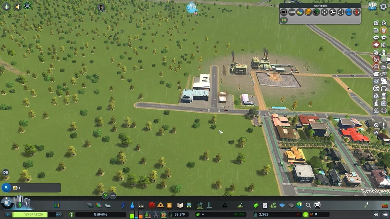
In the future I plan to expand Smokestack City similarly to Granola Court. So I moved the taxi depot to the other side of the road. The hill really does rise fairly sharply nearby, so that does put a limit to how far as we can build. But we can still easily squeeze out another couple of streets of houses.

April was a busy time for that part of the city. At the end of the month, council construction crews moved through the area and widened the road considerably.

Sterling Hunter Avenue is the main route between the city and the farm out in the county. So a great deal of asphalt was laid down to facilitate faster movement.

Many complain that the five way intersections are confusing. But the residents just need to remember that traffic on Sterling Hunter is prioritized. Everyone else can wait their turn.

I'm sure many of you remember the grand opening of the city's second recycling center. I'm not sure who came up with the idea for biodegradable ticker tape, but they were a genius.

Right now both recycling centers, in theory, handle all of the city's garbage with capacity to spare.
In practice, the landfill usage will be up above 42% before the end of this recording session

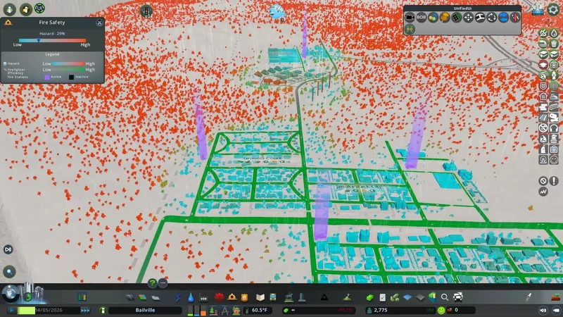
Fire coverage is, as ever, an ongoing battle. We can mitigate a lot of it, but the trees are really dragging the score down. Each little red blip counts against us. 

There is a lot of unused land just to the south of Bailville. Land we can use. In the future, I am going to be putting in at least two more neighborhoods here. One to the south of Old Town, and one to the south of the park, right up against City Hall. I also think the Desire Path waterfront is an ideal spot for a leisure district once we have authorization to paint those. I think a couple streets of nightclubs, bars, and theaters all would look fantastic nestled up against the quay.

This is my proposal for the next phase of the city's development.

Moving on, the Desire Path's chaotic flooding has been bothering the park's piers. Some mornings the owners report having to sweep out a lot of saltwater from their dining rooms. So I told my engineers to find a solution to the problem.

They told me that the bottom of the river bed is as smooth as polished marble. All other rivers in the world have interesting topography in the bed, and the lack of such is causing massive problems.

I told them to fix it by any means necessary. So for the better part of the summer, you may have seen their boats in the river. They were adjusting the riverbed.


I'm just randomly raising and lowering the terrain, pockmarking it. I also create a few ridges that create mini-waterfalls, giving the riverbed actual topography.

It looks like shit, but it works. It actually works.

These are actually the start of more of those freakish waves.

And these actually make the river flood over the quay walls.

It was a tumultuous couple of months. At one point, the riverbed was almost completely dry. But once the changes settled down, the river stopped doing its best tsunami impression.

Just to be safe, I ordered a Disaster Response Unit be founded.

They decided to build their headquarters at the corner of Triumph and Water Way.

Come the start of autumn, with their work in the river completed, my engineers were sent to an empty plot of land out in the county to start leveling off more of the hill that Bail Acres was built into.

The plan here was to create a small community, separate from Bailville proper, to act as a proper bedroom community for Bail Acres.

With some clever use of retaining walls, the community won't have to look at a rather ugly cross-section of earth and rock.

Spring Gardens finally hit level 3 and we got two whole gazebos. Yay.


Fun fact, Eric and the Dread Gazebo was written by Richard Aronson. That name might not mean a lot to some of you, but he's a voice actor from a previous LP I did. Which one, though?
 "Ohh, which indeed, Miss Mayor?"
 I can never quite escape that owl, can I?

The new community was planned out using fairly new techniques. The idea itself goes back decades - a densely-populated series of streets that have almost no traffic and are primarily for walking. But the policies to implement such an area have only become standardized fairly recently.
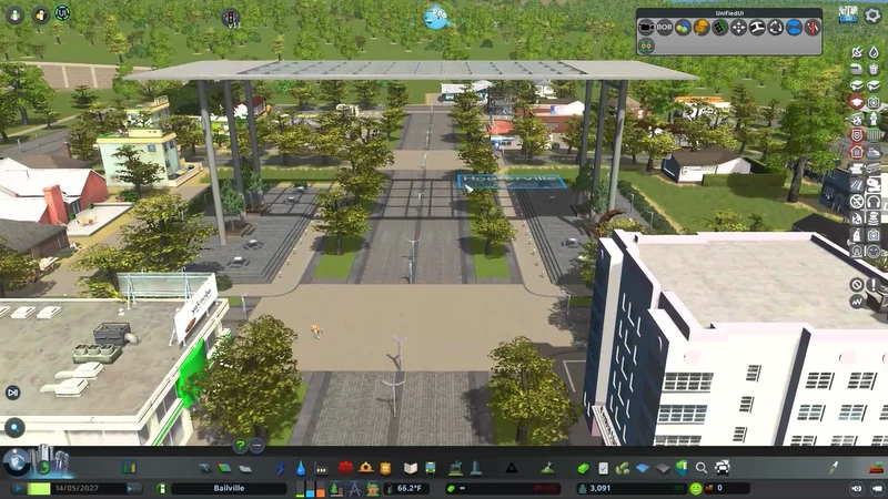
This new community is going to be a pedestrian area. These are generally meant to be inner-city areas that are only for walking. But there's nothing stopping you from doing what we're doing here and using one to create a ped-only village.

Paint it big first and then we'll work it back.

I can't decide if the boys in the planning department have a sense of humor or not. They claim it is because the area is a roosting ground for owls, thus the name. Nobody was sure if they understood that it can also refer to specific parts of the body as well.
Hooterville is the closest town in the old sitcom Green Acres, and that's where the name came from. But it also sure sounds like Boobville.

This is some of the problems I keep running into. For no reason whatsoever, the buses feel the need to circle this road. I don't know why.

Eventually I just moved the bus stops and suddenly the most attractive path was no longer through a residential area.

More messing with bus stops... I eventually put in a pedestrian path into Bail Acres in order to keep people off the roads. It actually works wonderfully!

Anyway, pedestrian areas need a service point. All deliveries and garbage are routed through this building, and it has to be placed in the pedestrian area.

We could put it here, but that would mean all the cargo traffic gets routed right to the doorway of Hooterville. So what if we did this instead?

You see, if we expand the Hooterville limits to this new street we made and then erase the bit in between, then Hooterville can exist on both sides of the highway access road.

And now the access point has its own dedicated road to service it that doesn't inhibit nearby traffic. It's win/win!

We decided that cobblestone streets would look lovely in Hooterville. They give the whole area a rustic charm. The core of the area is a simple grid of streets, but when we expand it in the future, we can lay more interesting cobblestone paths then.

Retractable bollards prevent most traffic from entering Hooterville's streets. Because it's primarily for residents, emergency vehicles still need ways to enter to get to the houses within. But no residential traffic is allowed on those cobblestone roads.

Hooterville is something of a trial run of the concept in Bail County. If it's successful, I would like to put in a couple more in the city limits. I'm picturing a large walk-only residential neighborhood near the park.

- Deliver Everything - Delivers everything to service points. Increases the load there. If you build like we have, this is not necessarily a downside.
- Slow Driving - Extremely low speed limits for roads in the pedestrian area. This has more of an effect if you put them in the middle of your city.
- Street Music - Increases happiness in commercial zones. Slightly increases noise pollution too, but eh.
- Sugar Ban -
 Average lifespan of citizens in the zone increases by 20%. This also increases crime by 20% because it creates a Whatchamacallit Black Market. No really, crime goes up because citizens are now creating speakeasies where they can buy and sell Skittles.
We're using street music here. Though we could also say to deliver everything and it wouldn't be a big deal.

Finally, to give the Hooterville owls somewhere to roost, we lined the streets and paths with local species of broad leaf deciduous trees.

And because I think it promotes a sense of community, the main gate into Hooterville has a little plaza on both sides of the 'road' where Bail County residents can set up food trucks. Let me tell you now, you haven't lived until you've had a pulled chicken sandwich from BB Qing's truck.
Anyway, that's all the time we had for this morning's meeting. I will actually be cutting the ribbon at this afternoon's grand opening of the Hooterville Glass-top Plaza. So we don't have a lot of time for questions and comments, but I can take a couple.
This one was about half as long as the last one and felt a lot breezier to write. I also wanted to get out the basics on laying down a pedestrian area.

They look really, really good when done right. All that is 100% pedestrian only. I actually find that the self-sufficient homes, like we have in Granola Court, look fantastic in pedestrian areas. ESPECIALLY surrounded by dense trees. So we'll probably be doing that when it comes time to build a forestry area.